
Authors: Sébastien Garrigues, Pierre Vanderbecken, Patricia de Rosnay, Jean-Christophe Calvet, Richard Engelen
Reducing the uncertainties in the prediction of the land carbon sink, which represents the largest source of uncertainties in the global carbon budget, is paramount for the preparation of the Copernicus anthropogenic CO2 emissions Monitoring and Verification Support (CO2MVS) capacity.
One of the objectives of CORSO is assessing the potential of assimilating solar-induced chlorophyll fluorescence (SIF) satellite observations to consistently constrain water and carbon fluxes over land.
Assimilating satellite observations requires an observation operator to predict the model-simulated counterpart of the remotely sensed observation. Machine learning (ML)-based observation operators are good alternatives to process-based models which are generally computationally expensive, more complex and associated with large uncertainties over land.
We present here the work conducted with the SIF assimilation in
the Integrated Forecasting System (IFS) at ECMWF and
the Land Data Assimilation System (LDAS) SURFEX at Météo-France.
SIF assimilation in the IFS at ECMWF:
At ECMWF, SIF data assimilation was developed and the impact was assessed at global scale in the IFS. ML-based observation operators based on the gradient boosted trees model (XGBOOST) and using a distinct set of predictors were developed and tested in the ECMWF LDAS to analyse Leaf Area Index (LAI) using a simplified extended Kalman filter. The updated LAI variables were used in the IFS coupled model forecast experiments and the impacts on the prediction of Gross Primary Productivity (GPP) were evaluated. The ML model directly trained on the satellite LAI has higher performance scores than the one trained from the IFS model fields and the LAI climatology. It results in more accurate updated LAI evaluated against the Copernicus Land Monitoring Service (CLMS) satellite LAI dataset.
Overall, the SIF data assimilation improves LAI over cropland (Figure 1) while degradations are seen over rainforests where the SIF signal is more uncertain and strongly depends on light use efficiency variability which is poorly resolved by the ML based observation operator. The GPP forecast produced from the updated LAI is improved over limited regions such as central Europe. However, the improvement in LAI does not systematically translate into improved Gross Primary Production (GPP) which is likely due to the presence of other sources of biases in the coupled IFS model.
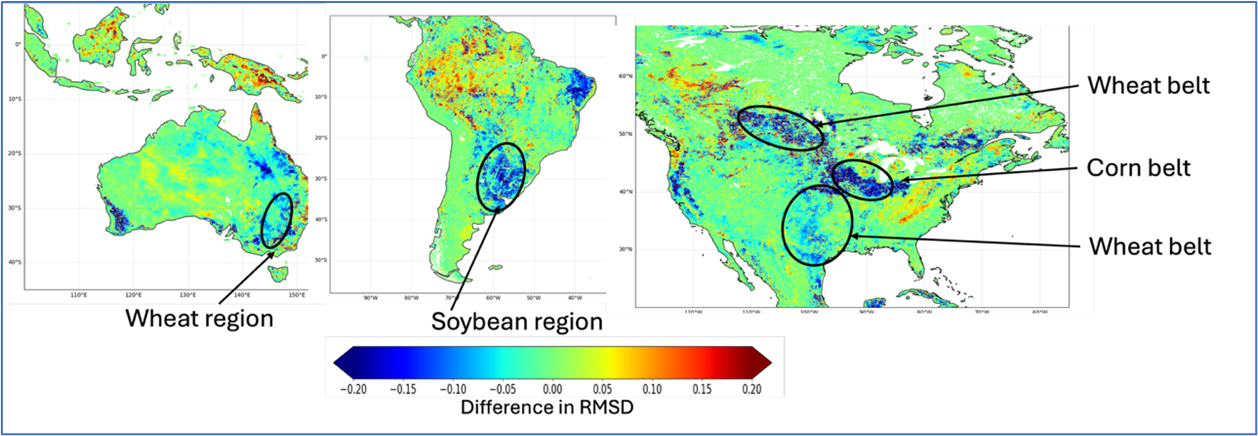
Figure 1: Regional impact of SIF DA shown as RMSD differences with vs without DA, between the IFS LAI and CLMS LAI for 2022 over North America, Australia and South America
These results demonstrate some potential of SIF data assimilation for the future CO2MVS. Limitations for some land cover types will be addressed in follow-on project activities combining prognostic LAI and SIF data assimilation.
SIF assimilation in the LDAS SURFEX at Météo-France:
To assimilate the TROPOMI-SIF product within the Météo-France LDAS, a deep learning operator was trained to replicate the product. This operator was then used as the observation operator, in line with the ECMWF methodology. Once the required level of accuracy was achieved, assimilation experiments were conducted over the Spanish Ebro basin at a resolution of 0.1° between 2018 and 2021.
The Ebro basin was selected because verification in situ and airborne observations were available from the Land Surface Interactions with the Atmosphere over the Iberian Semi-Arid Environment (LIAISE) field campaign in July 2021 (Boone et al., 2025; https://doi.org/10.1016/j.jemets.2025.100007). The area includes an intensively irrigated region within a dry zone. Figure 2 shows the estimated monthly average LAI in August 2021 in the open-loop experiment, alongside the results of assimilating TROPOMI-SIF.
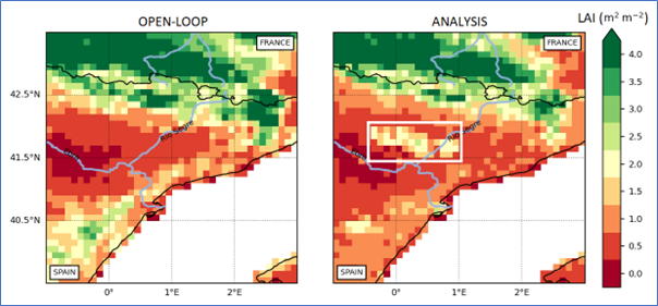
Figure 2: Leaf Area Index (LAI) simulated by the ISBA land surface model of Meteo-France over the Ebro basin with (right) and without (left) assimilation of SIF in August 2021. The irrigated area is highlighted after assimilation (within the white rectangle).
The irrigated area between the Ebro and Rio Segre basins is clearly visible on the map showing the assimilation experiment results. This demonstrates the benefit of assimilating SIF to improve vegetation monitoring.
Images courtesy of the project team.